

24 เม.ย. What’s new in ArcGIS Online 2023
ArcGIS Online เป็น web GIS ที่เปิดให้ผู้ใช้งานได้ทำความเข้าใจโลกรอบตัวเรา ผ่านการใช้งานแผนที่บนเว็บแบบ interactive เพื่อเชื่อมต่อผู้คน สถานที่ และข้อมูล เข้าด้วยกัน บน ArcGIS Online มีทั้ง styles และเครื่องมือการวิเคราะห์เพื่อการทำ location intelligence คุณสามารถใช้งานโซลูชันแบบ cloud-based ได้อย่างเต็มรูปแบบ หรือใช้งานร่วมกับ ArcGIS Pro บน Desktop เพื่อขยายขีดความสามารถไปอีกขั้น
ในรอบอัพเดทประจำเดือนกุมภาพันธ์ ปี 2023 นี้ มีฟังก์ชันใหม่ ๆ ใน Map Viewer มากมาย ได้แก่ spatial analysis tools รวมถึงการยกระดับความสามารถอื่น ๆ ในหน้าเว็บของ ArcGIS Online เราได้รวบรวมเรื่องเด่นมา ดังนี้
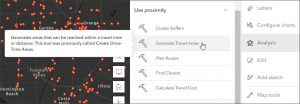
Map Viewer
Map Viewer เป็นช่องทางที่ดีที่สุดในการสร้าง แก้ไข และเรียกดู web map บน ArcGIS Online
ในการอัพเดทครั้งนี้ Map Viewer มีเครื่องมือการวิเคราะห์ที่ก่อนหน้านี้มีให้ใช้งานได้แค่บน Map Viewer และยังมีเครื่องมือที่เพิ่มมาใหม่เฉพาะบน Map Viewer ด้วย
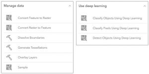
ArcGIS Image for ArcGIS Online
เป็น SaaS extension ซึ่งเป็นส่วนเสริมบน ArcGIS Online ใช้สำหรับ host ข้อมูลภาพ (imagery) visualizeวิเคราะห์ และเผยแพร่ข้อมูลภาพ ในอัพเดทครั้งนี้ ได้มีการเพิ่มเครื่องมือการวิเคราะห์ข้อมูล raster เข้ามาใหม่จำนวน 24 เครื่องมือ
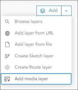
Media layer
สามารถเพิ่มเลเยอร์ที่เป็นรูปภาพเพื่อประกอบใน web map ได้ ประเภทไฟล์ที่รองรับคือ .jpg และ .png อีกทั้งสามารถย้ายตำแหน่ง และหมุนรูปภาพได้ตามต้องการ
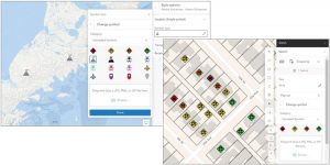
Upload Image symbols
ผู้ใช้งานสามารถอัพโหลดไฟล์รูปภาพประเภท .gif, .jpg, และ .png เพื่อใช้เป็นสัญลักษณ์ (symbols) บน web map ได้แล้ว สามารถนำไปใช้ได้ทั้งบนเลเยอร์ปกติ หรือ sketch layer ก็ได้
ArcGIS Instant Apps
ArcGIS Instant Apps เป็น web mapping application มีเครื่องมือสำหรับการสร้าง apps ได้อย่างรวดเร็วและง่ายดาย ด้วยการใช้ express หรือ full setup modes และ templates สำหรับการเริ่มต้นสร้างแอปสามารถค้นหาได้ง่ายๆในหน้า home page ของ Instant Apps
ในอัพเดทนี้ มีการเพิ่มฟังก์ชันในการเอาเมาส์มาวางค้างไว้บนเครื่องหมายต่างๆในแอป เพื่อดูข้อมูลใหม่ๆเกี่ยวกับแอปพลิเคชัน
ArcGIS Experience Builder
เป็น web mapping application สำหรับการสร้าง web app ที่เป็น mapcentric หรือ non-mapcentric หรือสร้างหน้า web page โดยไม่จำเป็นต้องเขียนโค้ด เพื่อเข้าถึงกลุ่มเป้าหมายของของคุณด้วยประสบการณ์การใช้งานเว็บผ่านทางหน้าจอขนาดใดก็ได้ คุณสามารถเริ่มสร้างแอปพลิเคชันเองทั้งหมดหรือใช้ template สำเร็จรูปที่มีเตรียมไว้ให้แล้วได้ตามวัตถุประสงค์ที่คุณต้องการ
Widget ใหม่ที่เพิ่มเข้ามาในอัพเดทครั้งนี้
- add data sources to an app at runtime
- Business Analyst widget
- Histogram charts
- 3D slice tool

หากสนใจอ่านข้อมูลและรายละเอียดเพิ่มเติมเกี่ยวกับการอัพเดทครั้งนี้ สามารถดูได้ใน https://doc.arcgis.com/en/arcgis-online/reference/whats-new.htm หรือดูวิดีโอแนะนำได้ที่นี่ https://mediaspace.esri.com/media/t/1_ks4mcel6
ค้นหาศักยภาพของเทคโนโลยี GIS กับการประยุกต์ใช้ในอุตสาหกรรมอื่นๆ เพิ่มเติม