

24 Apr What’s new in ArcGIS Online 2023
ArcGIS Online lets you understand the world around you by using interactive maps to connect people, locations, and data. You get smart, data-driven styles and intuitive analysis tools that deliver location intelligence. You can use it as a complete, cloud-based solution or to extend and complement the capabilities of ArcGIS Pro and ArcGIS Enterprise.
The February 2023 update includes new functionality in Map Viewer, such as spatial analysis tools, plus other enhancements, and new capabilities throughout the ArcGIS Online website. Highlights are provided below.
Map Viewer
Map Viewer is the premier way to author, explore, and edit web maps.
With this update, Map Viewer has been enhanced with new capabilities and features, including the following:
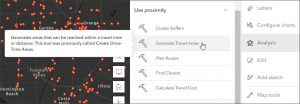
New analysis experience
Spatial analysis tools allow you to quantify patterns and understand relationships in your data. Most of the feature and raster analysis tools you’ve been using in Map Viewer Classic, plus a few new ones, are now available in Map Viewer.
ArcGIS Image for ArcGIS Online
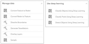
ArcGIS Image for ArcGIS Online is a complete software as a service (SaaS) extension for hosting, visualizing, analyzing, and sharing imagery. In this release, ArcGIS Image users will see 24 raster analysis tools added to Map Viewer.
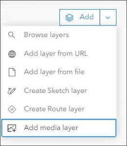
Media layer
A new media layer is introduced. Adding a media layer enables you to select a .jpg or .png image file that will be added to your map. Use the tools to position and rotate the image to place it in the desired location.
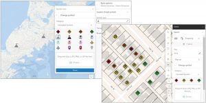
Upload image symbols
You can now upload .gif, .jpg, and .png images to use as symbols when styling your layer or creating a sketch in Map Viewer
ArcGIS Instant Apps
ArcGIS Instant Apps is the next generation of focused web mapping applications, featuring a streamlined experience that lets you build apps quickly and easily using express or full setup modes. All Instant Apps templates can found on the searchable Instant Apps home page.
ArcGIS Instant Apps templates includes several new and updated apps. Hover over the badges in the app cards to learn more about new, updated, or beta apps.
ArcGIS Experience Builder
Use ArcGIS Experience Builder to build modern mapcentric or non-mapcentric web apps and webpages without writing any code. Engage your audience through compelling web experiences on any screen size. Start from scratch or choose from an extensive library of templates that you can easily customize. Add advanced functionality with widgets you can drag, drop, and configure. Enjoy fully flexible layout options to build any web experience for any purpose.
New and updated widgets
The new Add Data widget allows users to add data sources to an app at runtime. The Business Analyst widget has redesigned settings, with options for presetting an infographic and location or letting users choose both at run time. Other widget enhancements include support for histogram charts, the 3D Slice tool, and the ability to choose which layers display in the Map Layers widget.

More information
For more information and additional details about this release, see the What’s new help topic . You can also watch an introductory video to see the new capabilities in action.
Unleashing GIS Technology’s potential in every industries