Logo Logo Logo Logo Logo
  • TH
    • EN
    • LA
    • KH
  • Products
    • Capabilities
      • Digital Twin
      • Location Intelligence
      • GeoAI
      • Cloud GIS
      • Mapping
      • Field Operations
      • Spatial & Data Science
      • Imagery and Remote Sensing
      • Real-Time Visualization & Analytics
      • 3D Visualization & Analytics
      • Data Management
    • ArcGIS
      • What is GIS?
      • About ArcGIS
      • ArcGIS Online
      • ArcGIS Pro
      • ArcGIS Enterprise
      • ArcGIS Location Platform
      • ArcGIS Apps
      • ArcGIS Reality
    • Geo-enabled Systems
      • ArcGIS Business Analyst
      • ArcGIS Hub
      • ArcGIS GeoBIM
      • ArcGIS Urban
      • ArcGIS Indoors
      • ArcGIS Mission
    • Esri Thailand Store
  • Solutions
    • Industries
      • Agriculture
      • Architecture, Engineering & Construction
      • Banking
      • Climate Action
      • Defense
      • Education
      • Electric
    • Industries
      • Government
      • Health and Human Services
      • Insurance
      • Manufacturing
      • Natural Resources
      • Public Safety
      • Real Estate
    • Industries
      • Retail
      • Smart City
      • Sustainable Development
      • Transportation
      • Telecommunications
      • Water
  • Support & Services
    • Esri Services
    • Utility Network Information Management
    • Documentation
    • Training
    • Product Management
    • Maintenance Program
    • ArcGIS Online Health Dashboards
    • Scope of Support
    • ArcGIS Trust Center
    • Premium Support Services
    • Esri Support Site
    • My Esri
  • News & Events
    • Esri Thailand Blog
    • Esri Thailand News
    • Esri Thailand Events
    • WhereNext Magazine
  • About
    • Esri’s Open Vision
    • About Esri Thailand
    • Contact Us
    • Geographic Approach
  • TH
    • EN
    • LA
    • KH
  • Products

    • Capabilities

      • Digital Twin
      • Location Intelligence
      • GeoAI
      • Cloud GIS
      • Mapping
      • Field Operations
      • Spatial & Data Science
      • Imagery and Remote Sensing
      • Real-Time Visualization & Analytics
      • 3D Visualization & Analytics
      • Data Management
    • ArcGIS

      • What is GIS?
      • About ArcGIS
      • ArcGIS Online
      • ArcGIS Pro
      • ArcGIS Enterprise
      • ArcGIS Location Platform
      • ArcGIS Apps
      • ArcGIS Reality
    • Geo-enabled Systems

      • ArcGIS Business Analyst
      • ArcGIS Hub
      • ArcGIS GeoBIM
      • ArcGIS Urban
      • ArcGIS Indoors
      • ArcGIS Mission
    • Esri Thailand Store
  • Solutions
    • Industries

      • Agriculture
      • Architecture, Engineering & Construction
      • Banking
      • Climate Action
      • Defense
      • Education
      • Electric
    • Industries

      • Government
      • Health and Human Services
      • Insurance
      • Manufacturing
      • Natural Resources
      • Public Safety
      • Real Estate
    • Industries

      • Retail
      • Smart City
      • Sustainable Development
      • Transportation
      • Telecommunications
      • Water
  • Support & Services
    • Esri Services
    • Utility Network Information Management
    • Documentation
    • Training
    • Product Management
    • Maintenance Program
    • ArcGIS Online Health Dashboards
    • Scope of Support
    • ArcGIS Trust Center
    • Premium Support Services
    • Esri Support Site
    • My Esri
  • News & Events
    • Esri Thailand Blog
    • Esri Thailand News
    • Esri Thailand Events
    • WhereNext Magazine
  • About
    • Esri’s Open Vision
    • About Esri Thailand
    • Contact Us
    • Geographic Approach
  • TH
    • EN
    • LA
    • KH
Search:
Drone Survey สำหรับโครงการโครงสร้างพื้นฐาน

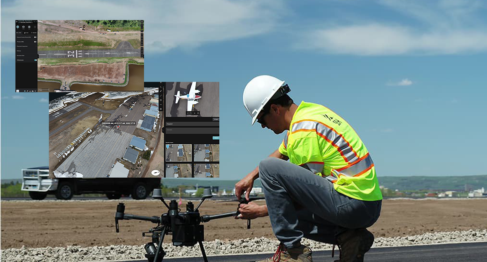
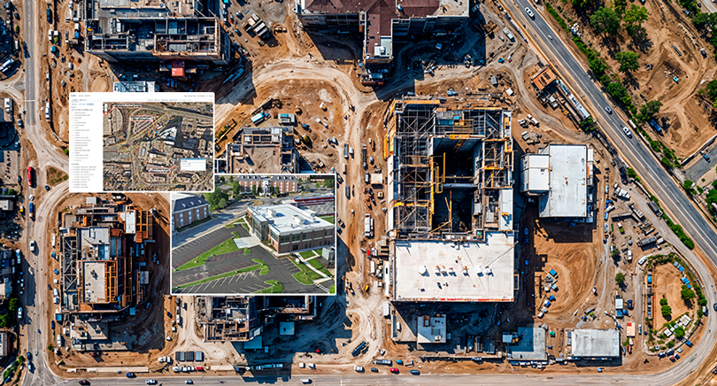
26 ก.พ. Drone Mapping และ GIS ช่วยยกระดับการก่อสร้างรันเวย์สนามบินในสหรัฐอเมริกา

Posted at 14:28h in Blog

...

Read More
Site Scan for ArcGIS, Drone Mapping and Drone Survey

04 ก.พ. Webinar “From Drone Data to Actionable Insights with Site Scan for ArcGIS”

Posted at 11:46h in Event

...

Read More
ระบบ Site Scan for ArcGIS ที่ใช้วิเคราะห์ข้อมูลโดรนของบริษัทก่อสร้างชั้นนำจากสหรัฐอเมริกา

04 ก.พ. Drone Mapping และ Site Scan for ArcGIS เปลี่ยนข้อมูลโดรนและ Imagery ให้เป็นการตัดสินใจที่แม่นยำด้วย GIS

Posted at 10:15h in Blog

...

Read More

Contact us

    ชื่อ - นามสกุล*

    Email*

    หมายเลขโทรศัพท์*

    หน่วยงาน*

    รายละเอียด*


    Subscribe to Esri Thailand news

    • ความเข้าใจใน GIS
      • GIS คืออะไร
      • Map We Love
      • ArcGIS Books
    • ArcGIS
      • ArcGIS
      • ArcGIS Online
      • ArcGIS Pro
      • ArcGIS Enterprise
      • ArcGIS Insights
      • ArcGIS Apps
    • ข้อมูลบริษัท
      • เกี่ยวกับบริษัท
      • ติดต่อเรา
      • หลักจรรยาบรรรณ
      • นโยบายป้องกันการทุจริต
    • นโยบายข้อมูล & เงื่อนไข
      • นโยบายความเป็นส่วนตัว
      • เงื่อนไขการให้บริการ

    Esri Hotline : 02 678 0212

    Email : esrith.contact@cdg.co.th

    ©2023 ESRI (Thailand) Co., Ltd. All Rights Reserved.