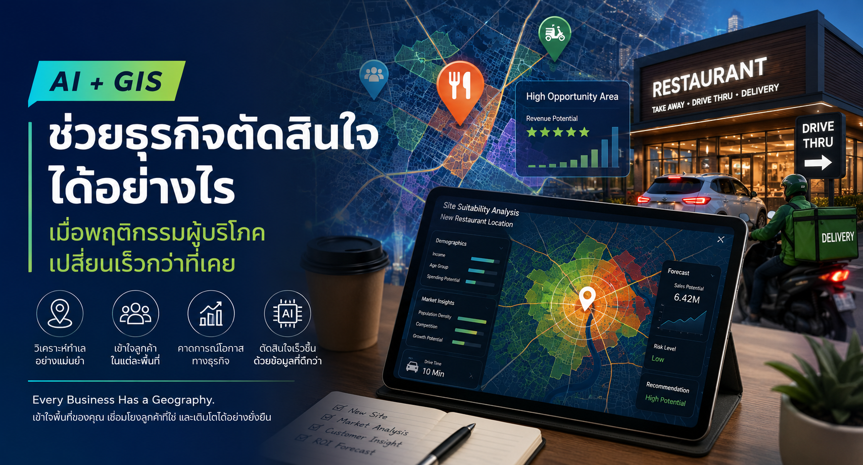
08 Apr ยกระดับการบริหารจัดการความเสี่ยงน้ำท่วมสำหรับธุรกิจด้วย ArcGIS for Flood Risk Management Posted at 15:55h in Blog ... Read More
31 Mar Drone Mapping ช่วยยกระดับการรับมืออุทกภัยในออสเตรเลียให้รวดเร็วและแม่นยำยิ่งขึ้น Posted at 16:02h in Blog ... Read More
30 Mar Drone Mapping และ GIS ช่วยยกระดับการก่อสร้างรันเวย์สนามบินในสหรัฐอเมริกา Posted at 13:45h in Blog ... Read More
23 Feb Professional Plus User Type ทำงานกับข้อมูลเชิงพื้นที่ครบวงจรแบบ End-to-End Posted at 14:15h in Blog ... Read More
04 Feb Drone Mapping และ Site Scan for ArcGIS เปลี่ยนข้อมูลโดรนและ Imagery ให้เป็นการตัดสินใจที่แม่นยำด้วย GIS Posted at 12:09h in Blog, Blog ... Read More
20 Jan Esri Thailand ผู้นำด้าน Location Intelligence Platform ที่ช่วยขับเคลื่อนธุรกิจ Posted at 17:44h in Blog ... Read More
06 Jan สิงคโปร์พลิกโฉมการบริหารท่าเรือสู่ Smart Port ด้วย Digital Twin Posted at 15:20h in Blog ... Read More
02 Dec Use Case: Republic Services บริษัทจัดการขยะในอเมริกาเหนือ ยกระดับประสิทธิภาพการเก็บขยะทั่วประเทศ เพิ่มความเร็ว ลดต้นทุนด้วยพลัง GIS Posted at 12:03h in Blog ... Read More
04 Nov จากข้อมูลเชิงพื้นที่..สู่การตัดสินใจระดับชาติ มาเลเซียใช้ GIS พลิกประเทศสู่ระบบสาธารณสุขที่ดีขึ้น Posted at 14:16h in Blog ... Read More
07 Oct ArcGIS + Next Gen Tech เทรนด์เทคโนโลยีแห่งอนาคต กับบทบาทของ GIS ที่ยกระดับทุกมิติของการวิเคราะห์ข้อมูล Posted at 14:31h in Blog, Blog ... Read More