
31 Jan Interconnecting GIS and Digital Twins
A modern GIS is a powerful technology for representing a holistic digital twins in spatial context . GIS allows you to abstract and model everything, bringing together many different information models.
For decades, organizations have been using GIS to create digital representations of the environment and their spatially diverse linear asset information models. But as business requirements have evolved, so have the complexities of these information models.
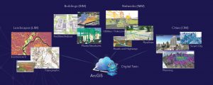
A modern comprehensive GIS connects these disparate information models:
Digital Twin Life Cycle
GIS creates relationships and streamlines workflows across systems and information models. Everything has a location, so location becomes the common key to integrate and model the digital twin’s complete life cycle. An integrated digital twin enabled through a modern GIS is not one single solution or product—rather, it is an ecosystem of capabilities and applications being bought together by GIS to support holistic and collaborative approaches. It is not one digital twin but rather many digital twins that are integrated and interconnected.
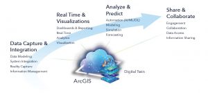
Below are the four elements for managing the information life cycle for a digital twin:
- Data capture and integration is foundational to a digital twin. Organizations need comprehensive, end-to-end data management. They need to capture the data, model it, integrate it, and then manage it and its associated attributes and behaviors throughout its life cycle.
- Real time and visualizations bring the data to life, taking information and creating a better understanding of what is happening now. Sensor technology enables real-time situational awareness combined with advanced visualization capabilities to virtually represent how the physical components are operating in the real world.
- Analyze and predict to move decision-making beyond just understanding the current operational state. Organizations must understand the past and view predictions of the future. They need to simulate and forecast expected outcomes as well as automate the decision-making process.
- Sharing and collaboration are enabled—via desktop and mobile devices— for both internal and external stakeholders. Digital twins are about collaboration—sharing information and getting it to those who need it, when they need it.
Data Capture and Integration
For many organizations, the need for data quality, information management, and system integration has long posed constraints to successfully deploying solutions to enable intelligent reporting and analytics. Traditional data-capture methods involved paper-based workflows, siloed integrations, or processes that were disconnected. This created information latency and eroded confidence in the data. Organizations need to be able to capture the transactional data from field operations and update source systems directly. In addition, they need to be able to manage and process complex, real-time, and high-volume datasets at scale from imagery and reality capture.
Field Operations: The mobile device has become the prime channel for communication. It is personal and always at hand, which makes it particularly useful for reporting incidents, updating records, and providing up-to-date information to end users in the field. By making it easier and more convenient for people to provide information and feedback, organizations can increase their knowledge and insight.
ArcGIS Field Maps is a premium app that is quick to deploy and allows you to manage the transactions of your digital twin in the field. Users—both online and offline—can capture data, perform inspections, take notes, and share information with the office.
ArcGIS Field Maps is an all-in-one app that uses data-driven maps to help mobile workers perform data collection and editing, find assets and information, and report their real-time locations. ArcGIS Field Maps is the go-to app, powered by field maps, that streamlines the critical workflows field personnel use every day. ArcGIS allows users to create, collect, manage, locate, and track while working in the field.
Imagery and Reality Capture: Organizations need to capture and create real world depictions of large construction sites, cityscapes, and entire regions. Digital twins at scale enable your organization to assess infrastructure, detect change, monitor the environment, and integrate with other information models. ArcGIS offers solutions to efficiently complete your workflows for managing, processing, sharing, and extracting information from your sensor imagery. Organizations benefit from advanced features for flight planning and fleet management for drone projects. Streamline the interpretation and extraction of features from the perspective of the real world.
SURE for ArcGIS is a surface-reconstruction software that empowers you to create photorealistic models of reality. It accommodates aerial mapping projects that use data captured with large-frame nadir and oblique cameras, as well as hybrid systems with lidar sensors. Without limitation in image resolution, you can produce 3D meshes, digital surface model (DSM) orthomosaics and point clouds on common workstation hardware, and cluster environments. SURE is simple to set up and operate and is compliant with mapping industry standards.
Real Time and Visualizations
Our world is transforming and rapidly becoming digital. Today, we are on the cusp of an Internet of Things (IoT)-driven technological revolution affecting most, if not all, industries. With billions of connected sensors deployed on assets and networks and in products around the world, companies are collecting and processing data at greater frequency and velocity. The challenge that continues to plague many organizations is not knowing how to make effective decisions from this data. Organizations are facing many new challenges and looking to technology to improve situational awareness, create operational efficiencies, and optimize all aspects of work.
While large-scale deployments of IoT technologies have improved the availability and timeliness of data, it can be difficult to connect these sometimes discrete and unstructured datasets. All sensors, assets, and networks have one thing in common: each is located somewhere. Location provides a common reference system to create relationships. An ArcGIS technology-based digital twin enables operations managers and staff to locate and monitor assets within a rich 3D, spatially accurate environment. The digital twin can also be incorporated with work management systems to identify the locations and specifications of assets prior to visiting the site. With the data available through a web browser, digital twins enable access to the information 24/7 on the user’s platform of choice, including desktop, tablet, and mobile devices. The dashboard metrics provide valuable insights that can be used to reduce maintenance issues, extend life cycles, and achieve new levels of optimization.
ArcGIS Velocity provides organizations real-time and big data processing and analysis capability in ArcGIS Online. ArcGIS Velocity allows you to import, visualize, analyze, store, and use data from IoT sensors. Highvelocity event data can be filtered, processed, and sent to multiple destinations, allowing you to connect virtually any type of streaming data and automatically alert personnel when specified conditions occur. You can also design analytic models to process high-volume historical data and gain insights into patterns, trends
Analyze and Predict
Access to the best information strengthens operational and strategic decision-making. Information has never been so abundant, and its ability to help organizations plan, respond, and coordinate has never been so pronounced. There is a growing and profound recognition that this insight not only improves current situational awareness but also is essential for understanding and forecasting future outcomes.
Some of the highest expectations around digital twins come from having the ability to use a high-precision digital twin to simulate, evaluate, and predict the future. In the energy industry, digital twins can be used to explore future demand of load based on population growth. In the architecture, engineering, and construction (AEC) industry, aggregated BIM information is used in the practice of virtual design and planned construction to detect possible conflicts or safety issues. At the scale of a city, planners want to be able to simulate future change, such as the shape of a new building, changes in a planned highway, or improvements to sea walls. Digital twins at all scales provide possibilities for simulations and analyses that can be used to understand and optimize current performance and forecast impacts of a potential change.
ArcGIS provides machine learning (ML) and artificial intelligence (AI) tools designed to solve complex spatial problems using geospatial artificial intelligence (GeoAI) to enhance the digital twin.
Below are the main patterns for GeoAI:
Object Detection
- Detection of objects from imagery/videos
- Land-cover classification
Change Detection
- Prediction
- Geospatial events and phenomena
Pattern Detection
- Statistically significant clusters and patterns
Share and Collaborate
GIS and mapping are essential for supporting a smarter world. GIS is a system for managing and applying geographic information, providing the fundamental language to create understanding. GIS connects people, organizations, and communities by improving communication and collaboration.
To create value from a digital twin, the information must be shared, allowing everyone to access and understand it. ArcGIS promotes user collaboration and interaction. Engagement starts with communication—connecting people in real time, using location-aware devices. ArcGIS empowers employees, customers, and executives with the information they need. Digital twins can be shared on any device via web maps, storytelling apps, or content-sharing hubs.
A story can effect change, influence opinion, and create awareness— and maps are an integral part of storytelling. ArcGIS StoryMapsSM can give your narrative a stronger sense of place, illustrate spatial relationships, and add visual appeal and credibility to your ideas.
ArcGIS HubSM is an easy-to-configure community engagement software as a service (SaaS) that organizes people, data, and tools through information-driven initiatives. Organizations can leverage their existing data and technology and work together with internal and external stakeholders to track progress, improve outcomes, and create vibrant communities.
Unleashing GIS Technology’s potential in every industries