
08 Sep Drones, 3D Buildings, and Construction Monitoring
The construction industry is poised for massive growth—if only it can overcome its productivity problem. Labor-productivity growth in the global construction business has averaged just 1 percent a year for the last two decades, according to estimates by the McKinsey Global Institute. That compares to a 2.8 percent uptick in the economy generally, and 3.6 percent in manufacturing.
By ratcheting up output efficiency to match the global productivity rate, the sector’s value could jump $1.6 trillion a year, according to McKinsey. That would be a much-needed boost as the industry looks to meet massive global infrastructure demands, which may cost $57 trillion by 2030.
To achieve those gains, business leaders are turning to advances in geospatial technology, drone-based imagery, and building modeling—the kind of cutting-edge digital tools industries across the board employ to accelerate efficiency and productivity.
Making Buildings Come to Life Digitally
These technologies have proven they can transform the design and construction monitoring process, as well as later stages of the project life cycle. Individually, they’re being adopted across the industry. Now, construction leaders are bringing them together.
Building information modeling (BIM) helps architects, engineers, and construction (AEC) firms visualize the interiors of structures in 3D. Planners can see on their screen what a structure will look like before construction, and the model can be updated as the building evolves. According to a KPMG study, 86 percent of the most innovative leaders in the engineering and construction industry have adopted BIM.
A geographic information system, or GIS, complements BIM by mapping and visually displaying the land and features surrounding a site. By showing the interrelationships between a project and the nearby terrain, GIS reveals how a structure will interact with the connected world. With that visibility, AEC planners can increase productivity and minimize costs from unexpected site impediments or late design changes.
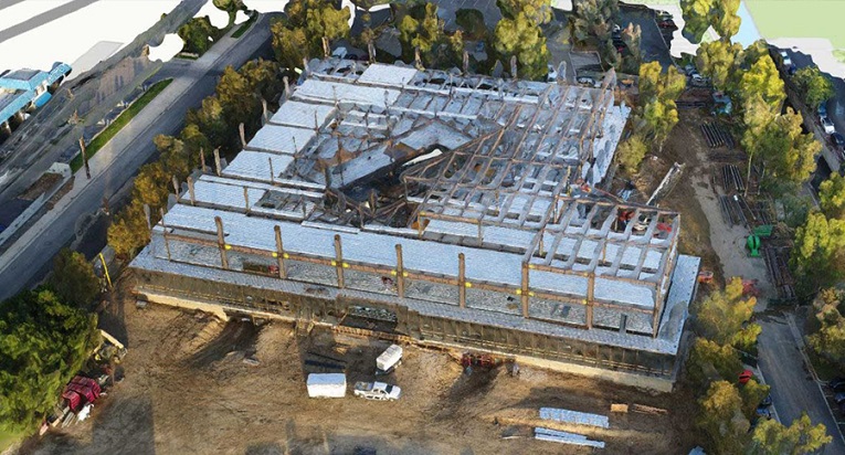
Tech-forward companies are integrating drones into workflows for additional productivity gains. With cameras that provide sharp, comprehensive visuals from any angle, drone imagery can be integrated with GIS and BIM so planners see highly realistic 3D models of construction progress at a glance.
In the past, GIS and BIM were siloed and could not easily share data. Now the two are reaching new levels of interoperability, giving designers and business leaders a seamless picture of a building under construction and a common platform for collaboration and communication with stakeholders. With the addition of drone imagery, managers approximate the experience of being on-site, but with the ability to rewind and fast-forward construction progress or observe a project from any angle.
Construction Monitoring in Action
The video below demonstrates how geospatial tech, BIM, and drone footage enable AEC leaders to track construction with a level of detail and interactivity unimaginable in the 2D era. A large building serving as the hypothetical jobsite can be grabbed, swiveled around, and zoomed in on.
Each floor of the building under construction can be peeled back, showing how the structure looks from the ground level all the way to the roof. The interlocking technologies of GIS and BIM make this 3D visualization possible.
The addition of drone imagery adds further layers of detail empowering construction managers, architects, and project decision-makers to see with pinpoint precision how the structure changes over time. The imagery captured from each type of drone can be viewed individually, or combined for a holistic view. If questions arise about a particular section of the site, or what was accomplished on a particular day, a user can roll back the timeline to view drone imagery taken on that date, from any angle needed.
In a field in which countless hours and millions of dollars are lost due to late design changes, disorganization, and poor communication, the integration of these digital tools can shift the construction industry into the fast lane.
A Circle of Construction Innovation
Monitoring construction with technologies like GIS, BIM, and drone imagery creates a productive feedback loop, enabling executives to adjust the project vision based on the latest developments, and fold those updates back into daily site work. The same pattern can be repeated during the maintenance and operation stages of a project.
In the United Kingdom and Asia, commercial and civil construction firms are already incorporating this kind of workflow throughout the life cycle of a project, thanks to the combined use of GIS and BIM. Integrating these technologies from project start to finish could give the construction and engineering industry the productivity gains needed to deliver higher-value work.
Unleashing GIS Technology’s potential in every industry
Read more