ArcGIS AEC Collections
Smart Assets
Management
Solution

3D Modelling

Real-time Integratic

Visualize a Collaboration
3D Modelling
Real-time Integratic

Visualize & Collaboration

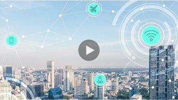
What is a Digital Twin ?
A digital twin is a virtual representation of the real world, including physical objects, processes, relationships, and behaviors. GIS creates digital twins of the natural and built environments and uniquely integrates many types of digital models.
Geospatial technology connects different types of data and systems to create a single view that can be accessed throughout the complete project life cycle. GIS enhances data capture and integration, enables better real-time visualization, provides advanced analysis and automation of future predictions, and allows for information sharing and collaboration.

Digital twin of the Port of Rotterdam
Europe’s busiest port utilizes a digital twin to track over 80 ships a day and 460 million tons of cargo per year, generating 3% of Dutch GDP.
A framework to create and integrate digital twin
Our world is rapidly transforming into a digital place. Digital twins are abstracting and modeling everything, improving business processes, reducing risk, optimizing operational efficiencies, and enhancing decision-making with automation to predict outcomes. Digital twins provide greater context to solve business challenges by creating relationships and streamlining workflows. Geographic information system (GIS) technology is foundational for any digital twin. Esri’s geospatial technology interconnects information, systems, models, and behaviors with spatial context, creating holistic digital representations of environments, assets, networks, and cities.


3D Modelling
Creating Digital Twins involves building 3D models that combine the structural information of buildings or infrastructure systems with GIS data, such as environmental features, wind directions, and soil layers, to provide a clearer overview of the projects and their environments.

ArcGIS CityEngine is a software for quickly creating 3D models. It simulates urban contexts with realistic building textures using the Procedural Modelling technique or creates models from a set of commands for multiple buildings at once.
ArcGIS CityEngine does not focus on creating one building model at a time, but instead uses the Rule Base Modelling, which involves using specifications as conditions for generating 3D building models. The details for each building depend on the details specified in the respective relevant rule bases. It can create multiple 3D building models simultaneously on a massive scale. It can also simulate the 3D details of the environment, such as streets, water bodies, and landscapes.
3D Modelling
Creating Digital Twins involves building 3D models that combine the structural information of buildings or infrastructure systems with GIS data, such as environmental features, wind directions, and soil layers, to provide a clearer overview of the projects and their environments.
ArcGIS CityEngine is a software for quickly creating 3D models. It simulates urban contexts with realistic building textures using the Procedural Modelling technique or creates models from a set of commands for multiple buildings at once.
ArcGIS CityEngine
ArcGIS CityEngine does not focus on creating one building model at a time, but instead uses the Rule Base Modelling, which involves using specifications as conditions for generating 3D building models. The details for each building depend on the details specified in the respective relevant rule bases. It can create multiple 3D building models simultaneously on a massive scale. It can also simulate the 3D details of the environment, such as streets, water bodies, and landscapes.

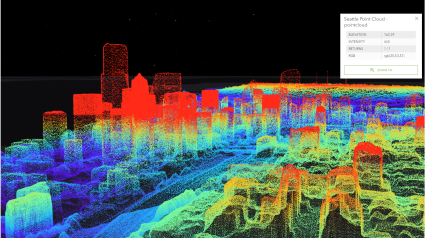
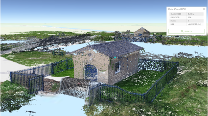
Drone collection

Drone collection is used to create more complete Digital Twins. The data collected from drones can be used to simulate real-world conditions of the projects, including buildings, infrastructure, and topography. This technology can also be used to create 3D maps or models of the areas using ArcGIS Drone2Map and Site Scan for ArcGIS applications.
Drone collection
Drone collection is used to create more complete Digital Twins. The data collected from drones can be used to simulate real-world conditions of the projects, including buildings, infrastructure, and topography. This technology can also be used to create 3D maps or models of the areas using ArcGIS Drone2Map and Site Scan for ArcGIS applications.

The integration of geo-enabled technology or GIS with Building Information Modeling (BIM) involves using 3D models to process data together with GIS information. This allows for a better understanding of the relationship between the projects and their spatial contexts, and for the analysis of the impact of the projects or external factors on them. This process is useful in managing assets and projects overall.

The integration of geo-enabled technology or GIS with Building Information Modeling (BIM) involves using 3D models to process data together with GIS information. This allows for a better understanding of the relationship between the projects and their spatial contexts, and for the analysis of the impact of the projects or external factors on them. This process is useful in managing assets and projects overall.


Real-time Integration
Integrating 3D modeling with real-time data from IoT sensors can enhance the completeness of Digital Twins, providing a real-time view of the projects, reducing errors, and improving asset management within the projects.

ArcGIS Velocity enables the connection with IoT sensors or devices to process, visualize, and analyze real-time data feeds and store data for in-depth analysis with ready-to-use tools that can flexibly scale to usage demands.
Real-time Integration
Integrating 3D modeling with real-time data from IoT sensors can enhance the completeness of Digital Twins, providing a real-time view of the projects, reducing errors, and improving asset management within the projects.
ArcGIS Velocity enables the connection with IoT sensors or devices to process, visualize, and analyze real-time data feeds and store data for in-depth analysis with ready-to-use tools that can flexibly scale to usage demands.

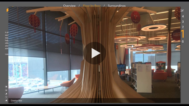
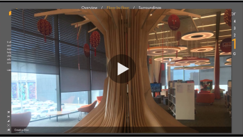
Visualize & Collaboration
Displaying 3D Digital Twins models allows for a comprehensive view of the projects and an immersive experience that simulates being in the actual locations. It also facilitates data sharing for stakeholders as well as easy and convenient data management.
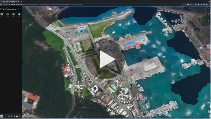
With the capabilities of various ready-to-use applications that can display 3D models of the projects together with aerial imagery data, the information will be interactive and updatable in real-time in cases where statistical readings are collected from various sensor devices. The data can also be displayed in real-time along with the BIM model. Users can also toggle building layers and view various details within.
Visualize & Collaboration
Displaying 3D Digital Twins models allows for a comprehensive view of the projects and an immersive experience that simulates being in the actual locations. It also facilitates data sharing for stakeholders as well as easy and convenient data management.
With the capabilities of various ready-to-use applications that can display 3D models of the projects together with aerial imagery data, the information will be interactive and updatable in real-time in cases where statistical readings are collected from various sensor devices. The data can also be displayed in real-time along with the BIM model. Users can also toggle building layers and view various details within.
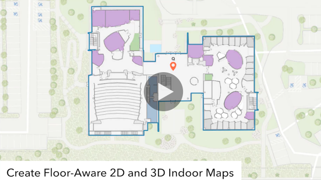

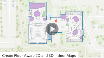
ArcGIS Indoor
is an application used for displaying, analyzing, and managing data within buildings. It utilizes building data from CAD and BIM to create floor plans and collect data on different components of the buildings. The system can search and filter data, calculate routes, and navigate. It can also be used to analyze asset management within the buildings, manage indoor space, and perform other related tasks.
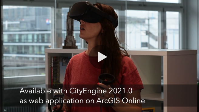

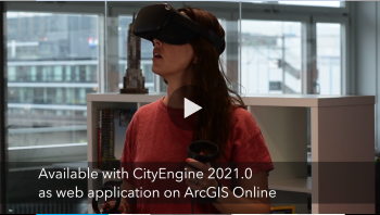
ArcGIS 360 VR
allows users to experience the virtual world through VR devices that provide a sense of being in actual locations with a panoramic 360-degree view. It also allows for the creation of a digital world, along with its environment and objects.
ArcGIS Indoor
is an application used for displaying, analyzing, and managing data within buildings. It utilizes building data from CAD and BIM to create floor plans and collect data on different components of the buildings. The system can search and filter data, calculate routes, and navigate. It can also be used to analyze asset management within the buildings, manage indoor space, and perform other related tasks.
ArcGIS 360 VR
allows users to experience the virtual world through VR devices that provide a sense of being in actual locations with a panoramic 360-degree view. It also allows for the creation of a digital world, along with its environment and objects.