How to secure the best location for your real estate business?
Location is everything in the hyper competitive real estate business. Those who act fast will gain advantage in grasping prime locations. That is why the GIS technology integrated with location intelligence is crucial to drive maximum profit. The GIS technology is key to an organization’s confidence in site selection.
ArcGIS for Land and Property Management
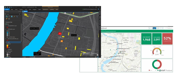
Land Analysis is application that equipped with tools to find lands in the location worthy of investment. For the purpose, land-based information can be combined with an investor’s business data for a weighted scoring calculation to locate potential pieces of real estate from a large number of possibilities.
Site-specific details that reflect the reality on the ground are indispensable for an accurate land analysis. The data allow investors to compare the land’s surrounding areas and distinguish different details in each piece. The reliable information and insight are a boon that helps investors make informed decisions under an intense competition and rapidly changing economic situation.
These details include:
- Street information and details including main and secondary roads, their width and number of lanes
- Water resources including rivers and canals
- Landmarks including shopping malls, office buildings, convenience stores, all kinds of mass transport stations, expressway entrance and exit as well as educational institutes
- Existing and future MRT routes
- City plans with land use classification
- Land appropriation areas
- Future projects such as real estate, shopping malls or restaurants
- Area-based population classified by age, gender, income and purchasing power according to each product
The programme supports a variety of work processes to meet every demand for real estate development.
Land Registration
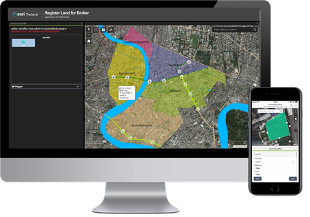
The application transforms paper-based land information into a digital form. It can draw up the land area and fill in details such as the contact name and address, land size, proposed sale price as well as title deeds. The digitized data allows for a convenient collection and further real-time applications.
Land Monitoring and Management
With the application, users can call up the piece of land that an agent or officer has entered through the Land Registration app on a real-time basis. They can also change its status, modify or update relevant information plus do an initial spatial analysis.

Land Field Survey
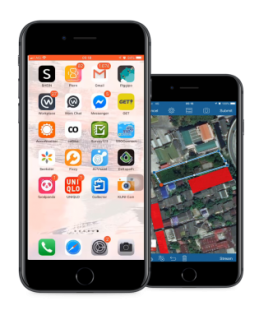
This application is designed for field surveyors to collect information about the land, market and other data. The entries can be readily accessed and analysed by mobile devices in the form of native application both on the IOS and android platforms. The App comes equipped with useful functions such as free draw to modify the land area, location collection, photo-taking and attachment. It works offline in case the site has no internet connection.
Land Executive Monitoring
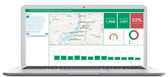
The dashboard with all land-related data can be used along with interactive maps and graphs and tables. It can be configured to support various presentation techniques be they the total number of lands, status, location, prices, sizes or a piece-by-piece summary to see the total number of lands and prices. Users can reconfigure the programme to display the result differently for future use cases.
Land Management
The programme makes use of location analysis to point to prime locations for investors. The system is full-cycled, starting from storing land data from agents as online maps then analyse their potential for investment based on business factors and area-based data.
The system enables a real-time access and monitoring of each plot’s buy and sell. It can also present complex data in the form of an interactive dashboard which allows executives to make decisions more effectively.
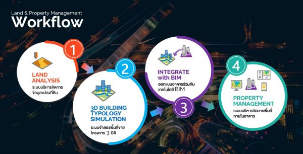
Apart from the land management functions, the ArcGIS programme carries tools that can provide a 3D building typology simulation of the project’s saleable area that also conforms to the city plan. The tools are not only more efficient in calculating the saleable area but the 3D simulation can also be used in integration with the CAD and BIM technologies as a guideline to design buildings. The ArcGIS’s Space and Property Management App completes the function with its ability to manage space both in and outside the building.
Our technology is a force that let you see what others can’t.
How to secure the best location for your real estate business?
Location is everything in the hyper competitive real estate business. Those who act fast will gain advantage in grasping prime locations. That is why the GIS technology integrated with location intelligence is crucial to drive maximum profit. The GIS technology is key to an organization’s confidence in site selection.
ArcGIS for Land and Property Management

Land Analysis is application that equipped with tools to find lands in the location worthy of investment. For the purpose, land-based information can be combined with an investor’s business data for a weighted scoring calculation to locate potential pieces of real estate from a large number of possibilities.
Site-specific details that reflect the reality on the ground are indispensable for an accurate land analysis. The data allow investors to compare the land’s surrounding areas and distinguish different details in each piece. The reliable information and insight are a boon that helps investors make informed decisions under an intense competition and rapidly changing economic situation.
These details include:
- Street information and details including main and secondary roads, their width and number of lanes
- Water resources including rivers and canals
- Landmarks including shopping malls, office buildings, convenience stores, all kinds of mass transport stations, expressway entrance and exit as well as educational institutes
- Existing and future MRT routes
- City plans with land use classification
- Land appropriation areas
- Future projects such as real estate, shopping malls or restaurants
- Area-based population classified by age, gender, income and purchasing power according to each product

Land Registration
The application transforms paper-based land information into a digital form. It can draw up the land area and fill in details such as the contact name and address, land size, proposed sale price as well as title deeds. The digitized data allows for a convenient collection and further real-time applications.

Land Monitoring and Management
With the application, users can call up the piece of land that an agent or officer has entered through the Land Registration app on a real-time basis. They can also change its status, modify or update relevant information plus do an initial spatial analysis.

Land Field Survey
This application is designed for field surveyors to collect information about the land, market and other data. The entries can be readily accessed and analysed by mobile devices in the form of native application both on the IOS and android platforms. The App comes equipped with useful functions such as free draw to modify the land area, location collection, photo-taking and attachment. It works offline in case the site has no internet connection.

Land Executive Monitoring
The dashboard with all land-related data can be used along with interactive maps and graphs and tables. It can be configured to support various presentation techniques be they the total number of lands, status, location, prices, sizes or a piece-by-piece summary to see the total number of lands and prices. Users can reconfigure the programme to display the result differently for future use cases.
Land Management
The programme makes use of location analysis to point to prime locations for investors. The system is full-cycled, starting from storing land data from agents as online maps then analyse their potential for investment based on business factors and area-based data.
The system enables a real-time access and monitoring of each plot’s buy and sell. It can also present complex data in the form of an interactive dashboard which allows executives to make decisions more effectively.

Apart from the land management functions, the ArcGIS programme carries tools that can provide a 3D building typology simulation of the project’s saleable area that also conforms to the city plan. The tools are not only more efficient in calculating the saleable area but the 3D simulation can also be used in integration with the CAD and BIM technologies as a guideline to design buildings. The ArcGIS’s Space and Property Management App completes the function with its ability to manage space both in and outside the building.
Our technology is a force that let you see what others can’t.