
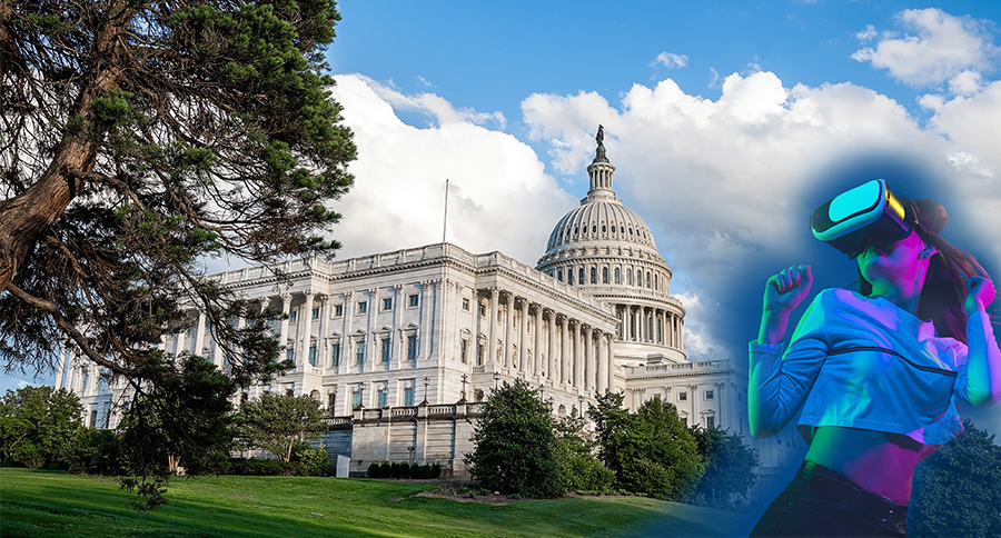
17 May DC Embraces Augmented Reality to Plan Its Future
Imagine touring Washington, DC, with an interactive virtual guide that shares fascinating historical details about buildings and monuments. You could listen to stories about people and events by simply pointing your device toward something to access relevant information.
This scenario explains the capabilities of augmented reality (AR), a technology the National Capital Planning Commission’s (NCPC) Policy and Research Division staff is exploring to both improve visitor experiences and analyze planning projects. In this pioneering approach, NCPC piloted AR in its realistic 3D “digital twin” of the capital.
Planners are starting to rely on Washington, DC’s digital twin for detailed 3D views and scenario planning as they work to protect the city’s iconic landscape while supporting continued development.
NCPC provides overall planning guidance for federal land and buildings in the National Capital Region by reviewing the design of federal and certain local projects. The agency oversees long-range planning for future development and monitors capital investment by federal agencies. NCPC conducts this work in collaboration with its District of Columbia government counterparts and other stakeholders.
Preserve Yet Grow
The new millennium ushered in an era of growth for Washington, DC, after nearly 50 years of population decline. The city added more than 100,000 people in less than 20 years, prompting development plans to accommodate new residents.
As new buildings and development projects come along, NCPC evaluates them while working with established planning constraints and laws. Among these laws and policies is the Height of Buildings Act—a law that dates back to 1910 when Congress established the city’s horizontal look and layout.
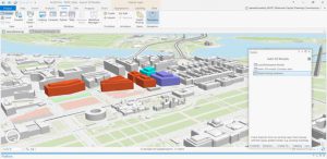
The local District government also has a say about the look of the city, and recently updated its zoning laws which hadn’t been rewritten since 1958. New zoning laws of course affect the city landscape. When NCPC staff created the interactive 3D application that serves as the foundation of its digital twin base model, they took this into consideration. Planners can use the 3D app to study how updated DC zoning codes might impact views. NCPC planners created a number of real-time visualization workflows to see and analyze the impact of policy decisions.
“We can now test different scenarios based on different inputs in real time, which gives us a sense of what types of policies we might create to preserve the character of the city,” said Kenneth Walton, architect and urban designer at NCPC.
BIM and GIS Combine
Back in 2011, NCPC launched the SW Ecodistrict Initiative—this was an effort to create a comprehensive plan for an isolated federal precinct south of the National Mall. The project team used the opportunity to plan for more energy-efficient federal office space while revitalizing the neighborhood with housing and retail establishments. The mixed-use idea integrates land use, transportation, and environmental planning with high-performance buildings, landscapes, and infrastructure.
NCPC planners worked with Autodesk, provider of Building Information Modeling (BIM) tools, to evaluate the energy consumption of individual buildings. They worked with Esri, provider of GIS technology, to gain a district-wide understanding of energy and the environment.
“We took the data from the individual buildings in BIM, and used GIS to evaluate the whole district,” Walton said. “We could look at what would happen to the entire district if different changes were made to the buildings from both an energy and environmental standpoint, both indoors and outside.” Today, the worlds of BIM and GIS are more tightly aligned as Esri and Autodesk work closely together. This gives planners, architects, designers, engineers, contractors, and builders a more seamless data flow between systems.
Experiencing Plans
Not long after the SW Ecodistrict Initiative, NCPC planners piloted EyeSite AR, an early proof-of-concept application that joins the digital and virtual worlds. Staff at NCPC developed the application alongside Esri professional services in 2012. By overlaying a detailed digital model onto reality, EyeSite AR gives planners a chance to experience a development before it’s built. A user can walk around, holding up their device to see how the model looks from different vantage points.
In the past, the primary method for visualizing proposed buildings in the field included driving stakes into the ground at the corners of the site. Helium-filled balloons would then be tied to the stakes and floated above to indicate the proposed building height. This method required evaluators to interpolate between paper plans and floating balloons to imagine a proposed building.
“Not everyone visualizes things in three dimensions in a good way or the same way,” Walton said. “Augmented reality allows us to have a discussion about impacts with something real to base it on, rather than six or seven different imaginations.”
Smarter Experience
In 2014, Washington, DC, embarked on a smart city pilot project. The PA 2040 (Pennsylvania Avenue 2040) project embedded Internet of Things (IoT) devices into city infrastructure, installing new LED streetlights equipped with sensors, and gigabit Wi-Fi hotspots.
This infrastructure further aligns the real and digital worlds. Instead of relying on distant satellite signals to provide location, the stronger local Wi-Fi signals provide hyper accurate location readings that translate into more believable AR experiences.
In 2016, NCPC teamed with the National Park Service and Van Alen Institute to explore how this tighter integration might provide informative commemoration experiences. They launched Memorials for the Future, a showcase of digital memorials visitors could explore via immersive virtual experiences.
“GIS and IoT smart city technologies allow you to geolocate virtual memorials in real space,” Walton said. “Rather than just having a static model, we could add video and animation to transport the public to the past or to allow them to record their impressions.”
Such mixed reality approaches are gaining momentum with rapid advances in mobile devices.
“The fact that almost everybody has the technology in their hands means far fewer barriers for people to get involved,” Walton said.
Unleashing GIS Technology’s potential in every industries