

27 Jul Water Utility Saves Hundreds of Thousands per Year with GIS
Posted at 04:25h
in Blog
White House Utility District (WHUD) in Tennessee serves a population of 90,000 in a 600-square-mile area, making WHUD the state’s largest water district. Like many utilities, WHUD faced the chronic concern of aging infrastructure that could leak, as well as the potential for more severe main breaks. WHUD sought a way to manage its infrastructure data to make more informed decisions about capital improvement spending as well as respond faster and more strategically to main breaks and water leaks.
What Did White House Utility District Do?
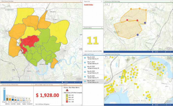
WHUD adopted a location strategy by using the ArcGIS®. The utility enabled an enterprise geographic information system (GIS) that integrated all critical information, including asset data and field crew updates. The GIS staff configured office dashboards and field applications that consumed the central geodatabase information on any device, anywhere. As a result of organization-wide access to GIS information and focused water-loss applications, WHUD was able to quickly isolate underground leaks for speedy repair, respond faster to urgent main breaks, and strategize capital improvement spending based on data-driven prioritization. Money was saved through not having to perform acoustic leak diagnostics, water was saved by faster discovery of and response to water loss, and capital improvement spending was more efficiently allocated. WHUD’s engineering team estimates the total direct savings to be $1 million per year, with more than $200,000 of that coming from early leak detection. Through better capital improvement expenditures that led to deferred bond issuing, WHUD has saved $32 million.“Because of the investment in ArcGIS, we’ve seen a great return. Thanks to the easy access [for] all employees, we are able to redirect work to other areas, such as leak detection, to help eliminate the amount of water that’s being needlessly put on the ground, saving hundreds of thousands of dollars each year.” – Amy Meadows
For more information please contact : esrith.contact@cdg.co.th