

21 Feb 6 Case Studies on Digital Twins
Digital twins are virtual representations of the real world including physical objects, processes, relationships, and behaviors. Geographic information system technology creates digital twins of social, natural, and built environments and uniquely integrates many types of digital models.
Currently, Digital Twins have been used in various organizations. according to the following example
1. Florida Utility Creates Digital Twin of Electric Assets with Highly Accurate Field Operations
The Utilities Commission of New Smyrna Beach (UCNSB) has been providing residential and commercial customers with electric, water, wastewater, and reuse water services for over 50 years.
When UCNSB’s transmission and distribution (T&D) assets were installed in the 1970s, the utility’s as-builts were recorded in CAD software. In 2014, UCNSB converted its CAD drawings into GIS features and the organization’s field teams began using the GIS maps in routine mobile work.
UCNSB acquired two Arrow Gold receivers from Eos Positioning Systems for the field teams to use with ArcGIS Collector during their routine work to capture data and create digital twins of the assets in the field. Information is updated in the field and synced with ArcGIS Online, and a data editor in the office performs a quality control check. Then the new data is merged into the production GIS database and made available to all. The turnaround time for the entire process is usually less than a day.
UCNSB has extended the use of the new system for the verification and correction of the utility’s entire asset database, creating a highly accurate digital twin that reflects the true location of all transmission and distribution assets.
2. Creating the Digital Twin of Grenada from Imagery Data
The island nation of Grenada recognized the need to create data products for urban planning, economic development, emergency management, and natural-disaster preparation that will support future decision-making. Using topographic lidar and 20-centimeterresolution
imagery for the whole country, the government of Grenada was able to create a digital twin at scale. This 3D representation of Grenada includes accurate depictions of roads, building features, power lines, streams, vegetation, and more.
This digital twin was used to create maps such as a susceptibility map to test how infrastructure would be affected by a landslide. To do this, staff used ArcGIS Image for ArcGIS Online to develop GIS data from imagery provided by the governments of Grenada and the United Kingdom.
Three-dimensional geospatial digital twins are a powerful tool for aiding natural-disaster resilience. These are the foundation for flood and storm-surge modeling, and Grenada now can see exactly which buildings and infrastructure would be impacted in different scenarios.
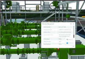
3. Gwinnett County Explores Digital Twins at Pump Station
Using Autodesk Revit, KCI Technologies developed a 3D building information model that is spatially accurate to within one inch and tied it to traditionally surveyed control points for a real-world location. The model was then converted to an Esri® ArcGIS 3D multipatch feature class format. In the GIS, assets and sensors were related to their functional systems and facility—achieving an easy-to-navigate 3D vertical hierarchy not present in most asset management systems. Moving from a model to the implementation of a true digital twin requires overlaying real-time data and storing it in the cloud for live and historical analysis.
To build a virtual representation of a site, information is integrated from a variety of sources, including lidar scans, subsurface utility locating, high-resolution drone imagery, and traditional surveys for ground control. The resultant point clouds, 3D surface meshes, and survey data offer a true and current as-built, often including abandoned and unknown infrastructure not present on plans.
“The model that was produced by KCI Technologies during this project proved that this type of information is not just for design engineers anymore. The model, as detailed and as complex as it is, can be made available in the field to frontline employees who benefit from it the most.”
– Charlie Roberts, Deputy Director (Gwinnett County Department of Water Resources)
4. Digital Twin Helps Amsterdam Airport Schiphol Optimize Operations
Amsterdam Airport Schiphol—the world’s 11th-busiest airport, the second-largest in terms of hub connectivity, and the main international airport of the Netherlands—facilitates the movement of passengers and cargo throughout the Netherlands and the rest of Europe. Schiphol implemented a digital twin known as the Common Data Environment (CDE), which organizes data from many sources—building information model data, GIS data, and data collected in real time on project changes and incidents as well as financial records, documents, and project portfolios.
CDE collects and processes data from remote sensors at the airport that are used in predictive maintenance. Within the 7,000-acre complex, the airport tracks and maintains more than 80,000 assets—both indoors and outdoors—ranging from linear networks, runways, and lighting systems to information booths and fire extinguishers.
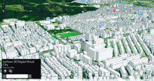
5. South Korean City Uses a Digital Twin to Meet Challenges
A South Korean city is using a digital twin to become a truly smart city by using its geospatial infrastructure to engage its agencies and the public to help meet challenges, both present and future.
Located on the northwest coast of South Korea and near Seoul, the nation’s capital, Incheon is a major industrial center. Incheon anchors the west side of the Seoul Capital Area, the world’s second-largest megaregion. As the world continues to urbanize, the region will get more crowded.
Incheon’s digital twin mirrors many of the city’s functions in real time. The real-world system it duplicates is no less complicated than Incheon itself. Since the beginning of the year, the Incheon digital twin has grown to include six project areas: fire response management, traffic, urban sanitation, facilities management, urban development, and city revitalization.
Incheon’s digital twin is now being used to operate a flood-prediction monitoring system. This is an important development because the digital twin doesn’t just mirror the city as it is in the moment; it can be used to predict events caused by changes in conditions in the city.
6. Uppsala Creates a Detailed Digital Twin to Enhance Sustainability
City planners in Uppsala, Sweden’s fourth-largest city, are designing a new district with 33,000 new housing units to accommodate 50,000 new residents by 2050. Today, the municipality of Uppsala has 230,000 residents, and its population is expected to reach 350,000 by 2050—more than a 50 percent increase. Much of this expansion will occur according to Uppsala’s comprehensive plan, but an area equivalent to 250 city blocks is being designed around green growth concepts.
Uppsala planners are concentrating on a sustainable urban model that adds to residents’ quality of life, doesn’t subtract from biodiversity or degrade the environment, and cuts carbon emissions.
A detailed zoning plan and 3D model built with ArcGIS Urban help the planners visualize and present plans for the new city district.
The interactive 3D model gives users an impression of the future district in a way that written documents or 2D maps can’t, allowing users to zoom and fly around new urban areas and get a good sense of what is coming. For city staff, the ability to quickly make changes and see the impact of alternative designs is helping to drive the adoption of new workflows and the use of new tools.
Unleashing GIS Technology’s potential in every industries