
11 Mar What’s new in ArcGIS Survey123 (Updated February 2022)
ArcGIS Survey123 is a powerful survey creator that enables you to create surveys to collect data and share surveys with your audience. It comes in 2 components: Survey123 Web Designer lets you quickly create surveys with a drag-n-drop interface on a web browser, while Survey123 Connect is a desktop application that lets you use an XLS Form to create more sophisticated surveys.
Let’s see what’s new in Survey123 Web Designer
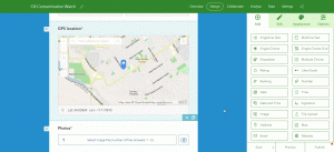
1. Use your own web maps in a survey
Up until this release, you could only choose a map already present in your organization’s basemap gallery. Now, you can select any web map, it can be a map you own or other maps from your organization.
2. Have your survey automatically get the respondent’s location
Map questions now support various options to determine the default location. Use these options to specify the behavior of your map such as Should the map automatically center when the survey is opened? Or when the user interacts with the map? What if instead the map should be centered at a predetermined location?
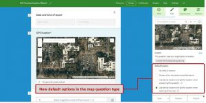
For example, you create a survey to report issues in your city. Since you know where the user is, you can automatically populate questions such as city, postal code or address where the incident happens.
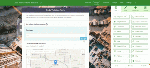
3. Use your own locators with the address and map questions
Many people may not know how to pinpoint the location of something in a map. Esri introduced the address question type. It helps respondents complete an address as they type.
What’s new in Survey123 Connect
Faster calculations and new calculation modes
Calculations in a smart form allow you to populate questions based on previously entered responses. The calculation execution in the Survey123 field app has been optimized to make your forms faster. You will appreciate the difference when working with very large forms.
Additionally, you can specify three different calculation modes in your questions:
- Auto: The calculation is triggered if the question is empty or if it has not been previously modified by the user.
- Always: Auto-calculates the value, even if the user has already entered a value.
- Manual: Use this option if you want the user to trigger the calculation manually.
See other enhancements for this release: https://doc.arcgis.com/en/survey123/faq/whatsnewsurvey123.htm
Unleashing GIS Technology’s potential in every industries
Read more