
30 Mar How Drone mapping and GIS are improving airport runway construction?
Posted at 13:54h
in Blog
Can drone mapping really help control costs idrone-mapping-arcgis-case-study/n large-scale construction projects? Case study from airports in the United States.
In an era where infrastructure projects are high-value and demand greater transparency in management than ever before , drone mapping and GIS systems are no longer mere supplementary tools but have become core components of cost control and risk management.
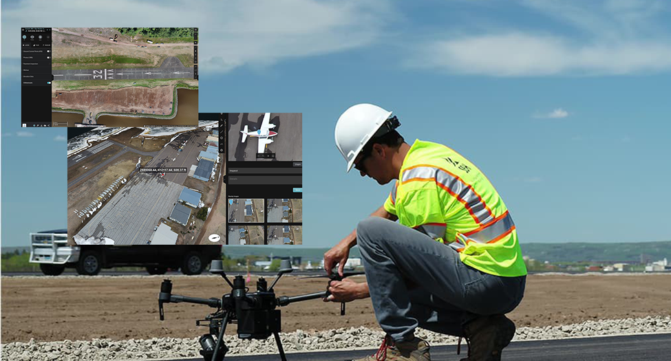
A case study from SEH (Short Elliott Hendrickson Inc.) demonstrates how, when drones and ArcGIS systems work together systematically, aerial imagery can be transformed into quantitative data useful for business decision-making, especially in highly complex construction projects.
Sky Harbor Airport in Duluth, Minnesota, has been operating since 1939 and is situated on ecologically fragile natural land. When obstructions were discovered in the runway path, including old pine forest, the airport needed to reposition the runway to meet aviation safety requirements. However, relocating the runway wasn’t just about redesigning; it was a project requiring an environmental impact assessment, the reclamation of acres of open water, and the management of massive amounts of construction materials under the supervision of multiple agencies.
SEH, as an engineering consultant, is responsible for everything from planning and design to coordinating agencies and overseeing construction work. This means that information must be accurate, verifiable, and clearly communicated to all stakeholders.
Business Challenge: How can you control hundreds of thousands of tons of material without weight data from scales?
One of the project’s key challenges is delivering approximately 200,000 tons of fill material to the construction site. The chosen method of transportation is by ship to minimize the impact on urban traffic. In typical projects, material quantities are usually based on truck weighbridges, but in this case, the material is loaded directly onto the ship, making it impossible to obtain verifiable weight data for accounting purposes. Weighing the entire ship is also neither convenient nor sufficiently accurate.
From a business perspective, this represents a significant budgetary risk. Without a way to verify the actual amount of work done, discrepancies in contractor payments or subsequent disputes could arise. Furthermore, the project must control its environmental impact, including the installation of sediment curtains in water areas, which require regular monitoring. Field inspections alone cannot provide a complete picture.
Digital Strategy: Transforming aerial photographic data into quantitative information for decision-making.
To address this challenge, SEH integrated Drone Survey into its core workflow, not just for taking photographs for reporting, but to create verifiable quantitative data. Aerial imagery from drones is processed via Site Scan for ArcGIS , a cloud-based drone mapping platform that supports everything from flight planning and image processing to enterprise-level drone data management.
Shifting from on-premises computing to the cloud allows teams to significantly reduce processing time and scale across multiple projects without investing in additional infrastructure.
The result is not only sharp orthomosaic images, but also 3D models and elevation data, which can be used to accurately calculate cut-and-fill soil volumes. This data becomes the primary reference for verifying the amount of material delivered to the construction site. Repeatable flight paths also allow for consistent comparison of data over time, reducing errors caused by different viewing angles or elevations.
Measurable Impact: Increased accuracy, reduced time, and clearer transparency.
When drone mapping is fully integrated with the ArcGIS system, teams can measure the area, volume, and changes of a site directly from the online platform, reducing field survey time and minimizing the risk of measurement errors. Volumetric data obtained from 3D models enables SEH to transparently verify figures from contractors, reducing disputes and increasing confidence in the budget disbursement process.
From an environmental perspective, aerial imagery from drones provides a clearer view of the location and effectiveness of sediment traps than ground surveys. Regulatory agencies can access the data online, accelerating the reporting process and enabling traceability. During project progress meetings, the latest aerial photographs can be presented to ensure all stakeholders have a shared understanding, allowing for decision-making based on factual data, not just textual reports.
Insights for construction and infrastructure organizations.
The SEH case demonstrates that drone mapping is not just a supplementary technology, but an integral part of digital transformation in engineering and construction. Aerial imagery can be transformed into a data asset that helps control costs, increase accuracy, and enhance project transparency.
For organizations managing large-scale projects, moving large volumes of materials, or operating under stringent environmental regulations, investing in a drone data management system integrated with GIS can be key to achieving a long-term competitive advantage.
Source: https://www.esri.com/en-us/lg/product/seh-case-study